
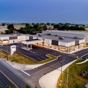
Martin’s Bike Shop
The Martins were in dire need of additional retail and warehouse space to accommodate their burgeoning internet business and the growth of their retail store.
Surveying & Mapping
 Before any surveying project commences, preparation work must first be addressed. Diehm & Sons surveyors extensively research the subject property as well as all adjoining properties. We plot all available property deeds and check for record monumentation calls along with any discrepancies in the lines of title. Detailed records research of recorded documents contained in the county courthouse such as property deeds, easements, rights-of-way, restrictions and recorded plans of record are gathered. We also utilize Lancaster County GIS (Geographic Information System) data to supplement deed plotting with available physical features and aerial photography.
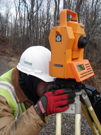
Once we’ve addressed our records research, we focus our expertise on traditional surveying methods, as well as electronic measuring, photogrammetric mapping and other state-of-the-art methods, depending on the needs and budget of our clients. The following are the main types of surveys we conduct.
Boundary Surveys
Boundary Surveys establish or reestablish land property corners and land boundary lines of ownership. Diehm & Sons utilizes the latest in electronic field equipment and employs methods best suited to perform the survey in an efficient matter.
- We perform hundreds of boundary surveys each year on properties of all sizes from a few hundred square feet to hundreds of acres.
- Most boundary surveys are followed up with the preparation of a Survey Plan depicting the boundary survey. It is often advisable to also prepare a new survey-based legal description for use in recording a new deed for the property.
- On smaller surveys, dubbed “mark my lot jobs”, we perform boundary surveys for homeowners who are looking to do improvement construction on their property.
Land Title Surveys
Land Title Surveys, often known as ALTA Surveys (American Land Title Association Surveys), are typically performed for commercial and industrial properties. These surveys are requested to meet the stringent requirements of title insurance companies and lending institutions. Detailed title searches are supplied to us for analyzing easements, existing improvements, floodplains, physical encroachments, and other concerns.
Topographical Surveys and Mapping
Topographical surveys and mapping show elevations and contours of the land as well as natural and man-made features such as streams, buildings, quarries, fences, walls, roads, wooded areas and more.
- Field “shot” topography involves thousands of data points being collected by the survey crew, which are then used to draft the desired contours and features.
- Detailed boundary and topographic surveys are performed for use by our in-house Civil Engineering and Land Development Departments or supplied to an architectural and engineering firm that does not have its own Surveying Department.
- All survey base plans are prepared in CAD (Computer Aided Drafting) format for use in Engineering and Land Development projects.
- On larger projects, Diehm will employ Aerial Mapping methodology by working with an Aerial Mapping Consultant, who will have a flight conducted over the site. From this collected data, Diehm can establish horizontal and vertical coordinates and elevations for use in calibrating the photography.
Control Surveys
Control surveys tie projects into the Pennsylvania State Coordinate System for horizontal datums and the National Geodetic Vertical Datum of 1988. These datums allow a common base for mapping projects and are becoming commonplace for uniformity in placing individual projects on the computer-generated state, county-wide or individual township mapping base plans. Diehm & Sons maintains an in-house database of our various control work projects performed over the past twenty years and maintains records of available state, federal, county or township monumentation. The use of GPS (Global Positioning Satellites System) equipment coupled with careful pre-and-post data processing allows us to reliably calculate the coordinate values to accuracies of within 1/8 to 1/4 of an inch.
Utility Surveys
Diehm & Sons performs detailed utility or corridor surveys and mapping for the design, replacement or improvement of public infrastructures such as roads, streets, bridges, culverts, sewer lines, water lines, intersection improvements, and traffic signalization. The surveying and mapping requirements are quite detailed involving locating and mapping all improvements including underground utilities and elevations and grades.
Construction Stakeout or Layout
Construction stakeouts are specifically for excavating and/or building contractors and utility companies. Beginning with a detailed CAD (Computer Aided Drafting) file either supplied by other firms or from our in-house Civil Engineering and Land Planning Departments, we study and coordinate stake point placement. The stakes are then set in the field by the survey crew, who also calculate “cut sheets” for use by the excavators or builders for guidance in the construction of the improvements. Diehm & Sons has “staked” hundreds of new facilities; roads, curbing, parking lots, sidewalks, building lots, sewer lines, water lines, fire hydrants, storm sewer inlets, and pipe systems, gas lines, power lines, stormwater management detention basins, buildings of all types, residential, single-family home, townhouses, apartments, office buildings, schools, industrial buildings, nursing homes, and churches.